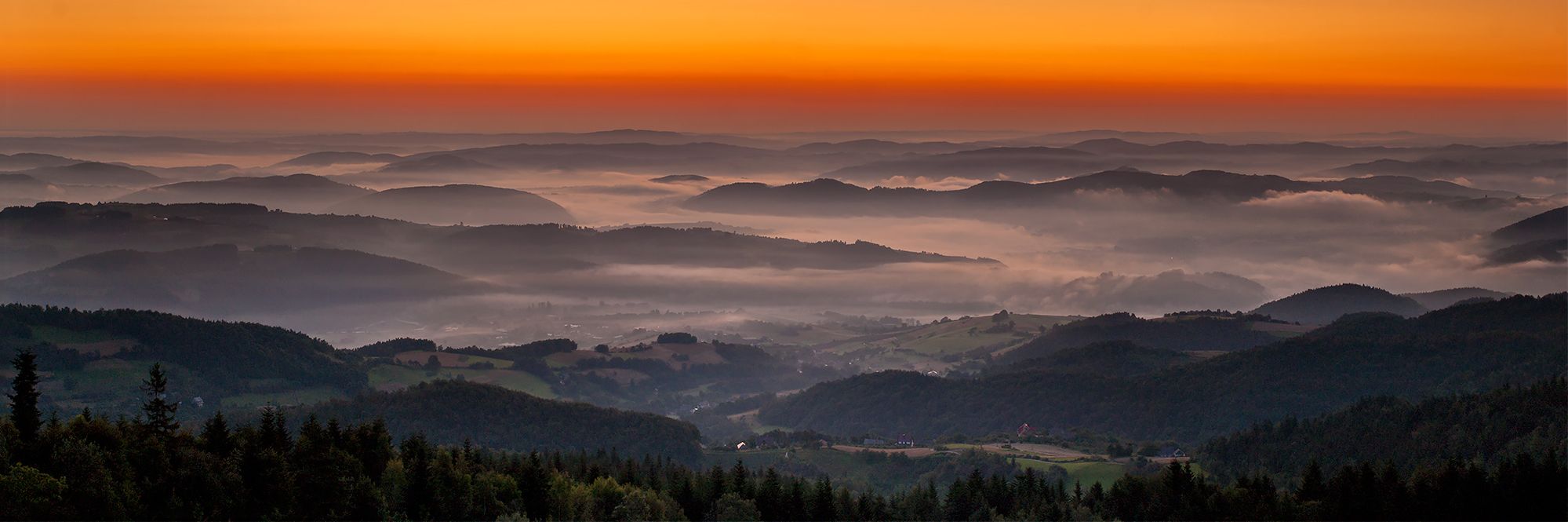
Convenient distance (about 50 km from Krakow) turned this part of Beskid Wyspowy to a frequently visited area. It offers many hiking trails following those made by Karol Wojtyła. The mild climate favours relaxation and tourism. It is recommended for children and elderly people. The tallest peaks of Beskid Wyspowy are: Mogielica (1170 m), Ćwiliń (1072 m), Jasień (1062 m), Modyń (1029 m), Luboń Wielki (1022 m), Śnieżnica (1006 m), Szczebel (976 m), Lubogoszcz (968 m), Łopień (951 m). Limanowa is the capital town of Beskid Wyspowy
The Pope's route in the Beskid Wyspowy consists of two parts: Rabczańsko-Mszański called Zagórzański, and Limanowski. The Zagórzański part starts in the center of Rabka Zdrój, from where on 21 June 1953, after a mass, Karol Wojtyła together with a group of young people went on Ćwiliń. They returned by train from Kasina to Rabka. Karol Wojtyła went to Cracow and the group went to Beskid Żywiecki. At the junction of hiking trails - in the Park Zdrojowy - there is a symbolic stone-statue of John Paul II, the Tourist. The Zagórzański hiking trail ends in Mszana Dolna.
The PTTK mountain shelter on Luboń Wielki named after Dunin-Borkowski was established in 1931 at the initiative of the Department of the Polish Tatra Society in Rabka. It is the only shelter of this kind in Beskid Wyspowy offering 20 beds and meals. Next to the shelter, there is a TV relay mast.
Glisne offers a panoramic view on Gorce and Beskid Wyspowy. In the local church there is a low-relief of the Last Supper made by a local artist from Mszana Dolna - Stanisław Ciężadlik.
The most interesting "curiosity" of Szczebel is the "Cold Hole - a sandstone cave on the northern slope (length 7m, width 1-2 m, height 4 m). It has two corridors - in the lower one, there is ice during almost the whole year.
The Pope's route from Lubień (350 m above sea level) via Czechówka (710 m above sea level) passes by Szczebel.
The local Retreat and Recreation Centre was founded by a priest Józef Winkowski in 1928. There is a new chapel; in the altar - a precious gift from the Holy Father John Paul II – a painting representing Our Lady of the Snows (the patron of Śnieżnica and the region). On 30 May 1930, the resort hosted Cardinal Stefan Sapieha. It is a charming place. The resort is open the whole year and offers 120 beds and meals. In winter, there is a ski lift.
The Sunday masses are celebrated at 10:00, and from May to August, also at 12:00.
Stara From the col, separating the massifs of Śnieżnica and of Ćwilin, stretch attractive views of Lubogoszcz, Kasina and Śnieżnica. When the weather is nice you can also see Babia Góra.
The old chapel has statues of St. Peter and Paul and an Epitaph. Karol Wojtyła was here on a trip on 22 June 1953 as a priest.
From the top of Ćwilin, you can enjoy beautiful views over the Beskid Wyspowy. If the weather is nice, you can even see Babia Góra and Tatry mountains. There is a Way of the Cross installed by the parish Jurków. There are springs with water of good quality and a lot of blueberries. On 22 June 1953, Karol Wojtyła ended his trip around the Valley of Mszana on Ćwilin. Then, he went to Rabka via Kasina.
This is a col between Łopień and Mogielica separating Jurków and Chyszówki from Słopnice. The inhabitants of the region of Limanowa founded a memorial obelisk in the memory of the the battle of Polish Legion with Russian Cossacks (24 November 1914), and of Marshal Rydz-Smigły. Next to it, there is a monument of the AK (Polish Army) and a cross. The col is the place where the Pope’s route crosses the Limanowa hiking trail.
A picturesque mountain called the Queen of the Beskid Wyspowy. On the western slope, there is a forest clearing called Stomorgi with a very nice view on Tatry mountains. Karol Wojtyła was here in June 1953 and February 1954. To commemorate this, the municipality of Słopnice built there a cross in the shape of a papal crosier.
From the top of Mogielica, the Pope’s Route leads in two opposite directions: along the yellow trail to Mszana Dolna and along the green one to Limanowa.
This place offers beautiful panoramic views. From Jasień, you can choose the following route: Jasień - Kobylica (924 m above sea level) - Ostra (780 m above sea level) - Mszana Dolna. It is a long and interesting hiking trail along the valley of Mszanka. In August 1963, Karol Wojtyła and his friends went from Mszana Dolna via Jasień to the valley of Kamienica.
Gorce National Park (GPN) - part of the Gorce Mountains on the southern edge of the zagórzański region. It is a great tourist attraction in the region. The National Park was established on 01.01.1981 and currently covers an area of 7000 ha (i.e. approx. 13% of the Gorce).
GPN has absorbed three previous reserves: "Orkan" (also called "Turbacz"), "VALLEY Łopuszna" and "Gorce". They have remained strictly protected areas. The same status is given to areas on the western slopes of the Gorce, in the valley Kamienica and below the peak of Kudłoń (all the areas under strict protection cover 2850 ha).
GPN covers the central part of Gorce, from Obidowiec to Gorc and from the northern slopes of Turbaczyk and Kudłoń until the upper part of the Valley Łopuszna and Magurka Borsuczyna. The highest peaks of Gorce are located in the GPN (except Turbacz 1310 m), and among them Jaworzyna Kamienicka (1288 m), Kiczora (1282 m), Kudłoń (1273 m), Gorc Kamienicki (1228 m), Mostownica (1251 m) and Czoło Turbacz (1258 m).
The GPN is aimed at protecting the natural, semi-natural and partly artificially created tree stands of different age, and the flora of Gorce (85 species), especially the floral peculiarities – i.e. alpine plants (17 species), subalpine (22 species) and rare plants.
The flora of the park, apart from the typical species of the Beskidy flora, includes species such as podejźrzon lancetowy, przetacznik alpejski and paprotnica górska - typical high-mountain plants of the Beskid mountains.
The flore of the GPN has a typical character of Beskid. Among mammals we should mention: ermine, Beskid deer, roe deer, weasel, lynx, skunk, otter, wild cat and wolf; birds such as: grouse, hazel grouse, black storks, eagle owls and woodpeckers. We can also find in the park buzzards, ravens and salamanders. The latter is the symbol of the GPN.
The GPN covers the former Carpathian Forest with old specimens of beech and fir.
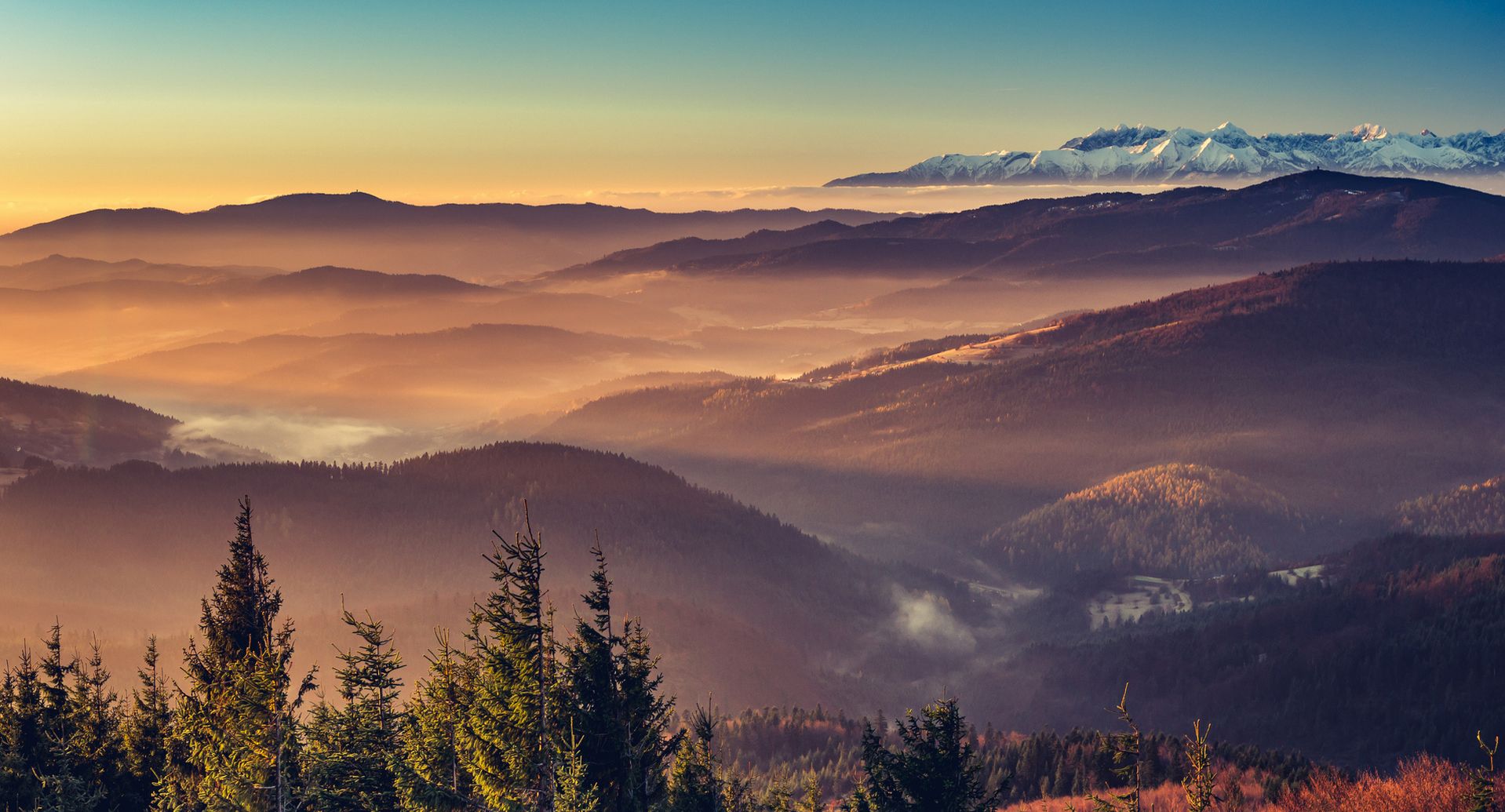
A special attraction of the park are the meadows, which are remnants of former intensive pastoral presence in the region. One can also admire the view on the surrounding mountains: the Tatras, Pieniny and Beskid Babia Gora.
There are 74 km of marked hiking trails in the GPN that lead through the most interesting areas of the park. You can also choose the unmarked paths which can be found on the tourist map of the GPN. For the amateurs of cycling, 53 km of marked trails. For horse-riding, there are 63 km of paths with different degrees of difficulty. It is also interesting to explore the “nature trail” - "Valley of the Turbacz Stream" in Koninki.
Hiking trails and walking paths leading to the park begin in the southern parts of the villages: Konin (the forester’s house "Na Potaszni"), Poreba Wielka - Koninki (at Recreation Centre and the forester’s house) and Poreba Gorna (the trail to the shelter on Stare Wierchy).
Turbacz (1310m above sea level) is the highest peak of Gorce, and the main point of Gorce tourism and skiing. The easiest way to reach Turbacz is from Koninki - Polana Tobolow (the upper station of the ski-lift "Tobolow").
600 m southeast from the summit, at 1280 m above sea level, at the western edge of the Hala Dluga is a big PTTK shelter, one of the biggest in the Polish mountains. It has 130 beds, central heating, dining room, cafe and lounge, with a beautiful view on the Tatra mountains. Near the shelter, there is a starting point of eight summer and winter hiking trails. In a small building nearby, there is a tourism center.
The ski season at Turbacz runs from late November to mid April. Skiing down into the valley is usually possible only until the end of March.
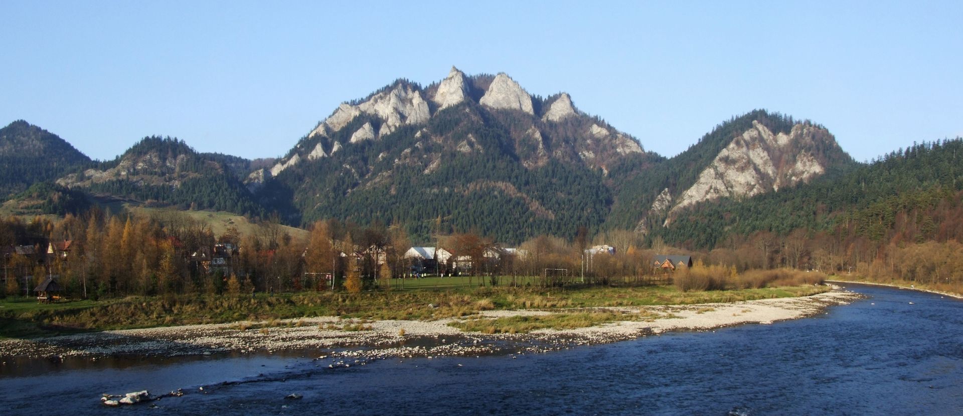
Pieniny, a small rocky group of mountains visible well already from Nowy Targ, extends from Czorsztyn village to Szczawnica town. From Sromowce Niżne, the Pieniny are cut by the Dunajec river, which following a winding course creates the Pieniny Gorge. The section between Sromowce and Szczawnica is known as the most beautiful part of the Pieniny range. Here, the river is surrounded by numerous steep white limestone slopes covered with lush vegetation. Every bend of the river reveals another spectacular and poetical view.
M. Orłowicz, “An illustrated guide to Galicya”, Lviv 1914
Thanks to its landscape and botanic richness, one of the most beautiful and valuable places in Europe.
The Dunajec river ravine divides the range into three parts:
* Pieniny Spiskie – extends between Dursztyn village and Niedzica, with the highest peak Żar (883 metres above mean sea level (ASL).
* Pieniny Właściwe – extends between Czorsztyn and Szczawnica and culminates with the Okrąglica peak (982 metres ASL) in the Three Crowns massif. By climbing this summit, a splendid, panoramic overview of the vast area can be gained and enjoyed.
* Małe Pieniny – extends between the Dunajec river (in the victinity of Szczawnica) and the Rozdziela pass in the east. The highest peak of Pieniny is the Wysoka mountain (1,050 metres ASL).
The most attractive part of the mountain range, from both natural and scenic points of view, is the Pieniny Właściwe range. The peaks here are beautifully jagged and the valleys often form rocky gorges. The northern faces slope gently into the valleys; the southern and eastern picturesque limestone cliffs (which are up to 300 metres high) drop down suddenly to the Dunajec river.
The most interesting nature tours:
• “Rafting” on Dunajec
• From Jaworki through Homole and Małe Pieniny to the valley of Dunajec
• To Sokolica and further through Sokola Perć towards Zamkowa Góra and Trzy Korony
• From Sromowce Niżne, through the Sopczański ravine through the Szopka col, up to Trzy Korony and then further to Krościenko.
The most interesting places in Pieniny:
• Pieniny National Park
• The ruins of the Czorsztyn castle
• Castle Niedzica
• Dam and reservoir Czorsztyn
• St. Bartholomew’s Church in Niedzica
• Wooden buildings of Kroscienko
• All Saints Church in Krościenko
• Wooden church in Sromowce Niżne
• Historic spa buildings in Szczawnica
• Szalaye’s manor in Szczawnica
• Park Zdrojowy in Szczawnica
• Orthodox Church in Szlachtowa
• Monastery buildings and church in Czerwony Klasztor
Tatra Mountains, Known as 'Polish Alps', and the Town of Zakopane, Poland's Ultimate Mountain Resort.
Alps-like Tatra Mountains, or the Tatras (Polish Tatry), is the highest range of the Carpathian Mountains and lie along Poland’s border with Slovakia. Two hour’s drive from Krakow one finds stunning views and pristine nature as well as the best skiing in winter and hiking, rock climbing, cave exploration, cycling, paragliding, etc. through the rest of the year. As tourism has been the area’s main business for over a century, visitors are thoroughly catered to. Annually some three million of them turn up in the Polish alps, mostly getting along well with wildlife preservation which is paramount seeing that twin national parks cover the whole of the Tatras both sides of the national border.
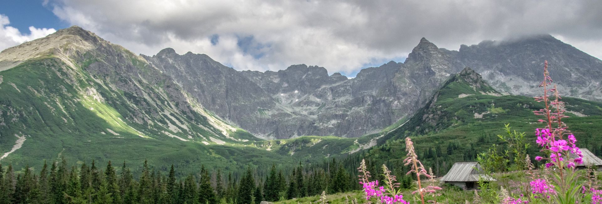
The Tatra Mountains rise to the greatest elevation in the entire northern half of Europe, with the 2655-meters (8711 ft) Gerlachovsky Stit in Slovakia and the 2499-meters (8198ft) Rysy peak in Poland. The range is 53 km long and takes up 785 sq km, the bulk on the Slovak territory. Three distinct parts make up the Tatra Mountains – the High Tatras, the Western Tatras, and the Bielskie Tatras. The High Tatras, with their dramatic vistas, steep peaks, sharp rocks, deep glens, and crystal lakes are the most attractive. At the same time the Western Tatras’ lower slopes clad in pine forests offer wider horizons, diverse wildlife, and somewhat less demanding tracks.
The most popular places in Tatras:
The Morskie Oko (“Sea Eye”) lake with its more elevated twin, the Czarny Staw lake – for great views, hiking and climbing. The Kasprowy peak (1985 meters above sea level) – for a cable car, great views and skiing. The Koscieliska Valley – for great views, easy hiking and wildlife. Dolina Pieciu Stawow (“Five Tarns Valley” ) – for hiking. Hala Gasienicowa – for hiking. The Rysy peak (2499m or 8198ft) – for the exclusive view on hundred peaks and twelve major lakes after an exciting climbing up the Polish highest mount and the most visited one in the all Tatras. The Orla Perc (“Eagle Ridge”) trail – for the thrills of quite demanding if amateur climbing. The Chocholowska Valley – for easy hiking, cycling, and wildlife. The Regle dales (when you are in Zakopane town) – for relaxed hiking, wildlife, and accessibility.
Read more @ http://i-tatry.pl/
34-730 Mszana Dolna, Ogrodowa 2 Street
© 2026 Folwark Stara Winiarnia - wszystkie prawa zastrzeżone.
Design by : LEMONPIXEL.pl / Booking by: HOTRES.pl